
| Project Overview | Oblique Aerial Images of the Lower Quinnipiac River | Landscape Analysis of the Lower Quinnipiac River Marshes | Quinnipiac Marsh Downloadable GIS Data |
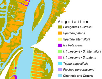
The report and GIS data on this website describe the landscape-scale patch structure of the tidal marshes in the lower Quinnipiac River. This website was developed as part of a project funded by the Quinnipiac River Fund to develop a geographic information system (GIS) in support of the Lower Quinnipiac River Conservation and Redevelopment Corridor Project that is being conducted by the Regional Growth Partnership of the South Central Council of Governments. The objective of this project is to revitalize economic activity in the areas surrounding the Quinnipiac River tidal marshes via brownfields redevelopment, community enhancements, and ecological restoration and conservation. As part of the ecological restoration and conservation efforts, we have developed a detailed landscape structure map of the marshes and their surroundings based on a series of black and white aerial photographs of the area in 1998.
 [Main page]
[About this site]
[Email us]
[Main page]
[About this site]
[Email us]
|