
| Project Overview | Oblique Aerial Images of the Lower Quinnipiac River | Landscape Analysis of the Lower Quinnipiac River Marshes | Quinnipiac Marsh Downloadable GIS Data |
|
Roman Zajac, Principal Investigator Additional GIS data provided by S. Anisfeld and J. Linn
Aerial photographs provided by South Central Connecticut Regional Water Authority |
|
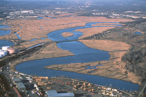
This website was created to provide information about the habitat structure of the tidal marshes of the Lower Quinnipiac River. Click on the links at the top of the page to read a description of the project and results of the analyses, to view oblique aerial images of the study area, or to download the GIS data developed as part of the project. |
|
Project funded by
|

|
|
Website by Neil Curri  [Main page]
[About this site]
[Email us]
[Main page]
[About this site]
[Email us]
|
|